Introduction
 |
| Credit to farm4.staticflickr.com |

The South Gate community is really one of a kind. It may not have any major attractions or landmarks, but the city still has much to offer. The cities intricate culture really makes it one of a kind.
I have lived in South Gate my entire life, and if I was to be able to go back in time, I wouldn't want to live anywhere else. The people of of the city and the friendly environment really makes this a great place to be.
I am excited to have the opportunity to share more about this wonderful city as we progress throughout the semester.
(photo credit to www.palapakings.comimagestown_center.jpg)
Environmental Setting
Location

Weather
Being that South Gate is within the city of Los Angeles, one can presume what the weather is like in the city.
 The city experiences subtropical like weather ranging from hot and dry summers to mild winters. I honestly believe that one of the greatest perks about living in Los Angeles is the weather. Although summers can be dreadful with temperatures at times surpassing 100 degrees Fahrenheit the mild winter temperatures make up for it. I think we are spoiled by the winter temperatures we have in the city. When temperatures drop to about 50 degrees, we begin to shiver and put on our Eskimo outfits. In other places in the U.S, the temperatures that we find freezing would be considered warm. Nevertheless, the cities temperature is pretty steady with temperatures usually ranging some in between 60 degrees and 80 degrees Fahrenheit.
 Since the city does not experience extreme winter temperatures, one can easily assume that snow fall is not a frequent occurrence. Although snow fall is EXTREMELY rare in South Gate, we do have our share of precipitation. Usually rain fall starts in the beginning of the fall season and increases in rate as the winter comes before gradually declining as summer approaches.
all information/statistics/photos in this section credit to city-data.com
Agriculture and Wildlife
 |
| Credit to morriscourse.com |
Environmental Hazards
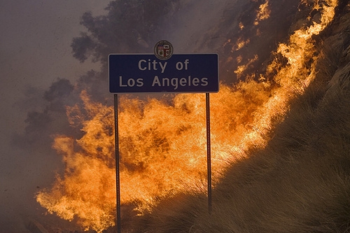 Due to the city being located in sunny southern California, one of the most common in the environmental hazards in the area wild fires. In late August of 2009, the region just north of Los Angeles experienced, "The Region Fire", which was one the largest and most deadliest wildfires in the history of Los Angeles; burning over 144,000 acres and killing two firefighters. (latimes.com)
 Along with wildfires, being that the city is located within the San Andreas fault, the city also hosts as a threat to earthquakes. According to citydata.com, "South Gate-area historical earthquake activity is above California state average. It is 2849% greater than the overall U.S average" (city-data.com). One of the most notable and recent earthquakes occurred on December 2012. The 6.4 magnitude earthquake off the coast of Baja California coast that was felt throughout all of Los Angeles. (dailynews.com)Moreover one of the most notable and popular earthquakes that occurred near the Los Angeles area was the famous 1924 Northridge Earthquake.
 |
| credit to earthquake solutions.com |
Historical Settlement
 |
| Credit to colapublib.org |
About 100 years following the Lugo Land grant, the area located at the south gate portion of the ranch came to be the City of South Gate. As the Lugo family began to grow, Don Lugo acquired the San Bernardino Rancho along with other regions and grants in the name of his children.
 |
| Credit to sogate.org |
The Lugo Land Grant kept within the family as it was passed down from generation to generation. Division of the Grant within the family lead to parts of the grant being sold to people outside of the family.
 |
| credit to sogate.org |
Political Economy
As mentioned earlier, South Gate's earliest settler relied and raising livestock and agriculture to get by. However, as the city grew to become more populated, it had to embrace a new industrial culture. With the elimination of farming land, the construction of houses made it necessary for the establishment of industries and businesses relatively close to home.
 Throughout the years, "Tweedy" has grown to become the city's most meaningful name. R.D Tweedy along with his family, have played a significant role in the development of South Gate's history throughout the years. Mr. Tweedy was born in Illinois in the year 1812, before moving the Southern California 40 years later. For generations, the large Tweedy family lived withing the city. Throughout that time, they acquired roughly 2,000 acres of land in which most of South Gate was built on. When South Gate began to industrialize, the downtown business sector of the city was named after the family. As the years progressed, the families name is still carried on, as the area has come to be known as the "Tweedy Mile".
(sogate.org)
Economic Sectors:
Due to the city's cultural transformation, the regions economy has virtually eliminated the need for a Primary economic sector. Little to no people in the city grow their own food and through industrialization, most of the city's raw materials have been abolished.
The Secondary sector play more of a role in the city's economy. Although some 90 years ago, the cities industrial movement was intended to provide factory jobs the cities residents, today that isn't the case. With the invention and popularity of the automobile, residents began to find employment outside the city. Today, according to citydata.com, the population's average travel time to work is roughly about a thirty-minute drive. Although most people drive out of town for work,some of the cities residents stay within the city on their work days. Several shipping and manufacturing factories are located in the outskirts of the town, providing employment for some residents.
The Tertiary sector probably provides the most significant role in South Gate's political economy. Most of the business in the Tweedy Mile consists of small, private, family-owned businesses. Along with small mom and pop shops, popular shopping markets and commercially franchised businesses are also located throughout the city. Aside from the Tweedy Mile, Firestone Blvd, is also a profitable market. As you travel down Firestone Blvd, you will see car dealerships and mechanic shops in every couple of blocks. Multiiple private medical and dental facilities are also scattered throughout the city. For the most part, you can find just about any one of your essential needs within the city.
The Quaternary sector also exists within South Gate. Although he city is not home to massive corporations or research facilities, the cities does contain nearly twenty schools in it's boundaries. Fourteen elementary schools, two middles schools, and three regional high schools make up the educational portion of the cities Quaternary sector.
city-data.com
Due to the city's cultural transformation, the regions economy has virtually eliminated the need for a Primary economic sector. Little to no people in the city grow their own food and through industrialization, most of the city's raw materials have been abolished.
The Secondary sector play more of a role in the city's economy. Although some 90 years ago, the cities industrial movement was intended to provide factory jobs the cities residents, today that isn't the case. With the invention and popularity of the automobile, residents began to find employment outside the city. Today, according to citydata.com, the population's average travel time to work is roughly about a thirty-minute drive. Although most people drive out of town for work,some of the cities residents stay within the city on their work days. Several shipping and manufacturing factories are located in the outskirts of the town, providing employment for some residents.
 |
| Credit to farm3.staticflickr.com |
The Tertiary sector probably provides the most significant role in South Gate's political economy. Most of the business in the Tweedy Mile consists of small, private, family-owned businesses. Along with small mom and pop shops, popular shopping markets and commercially franchised businesses are also located throughout the city. Aside from the Tweedy Mile, Firestone Blvd, is also a profitable market. As you travel down Firestone Blvd, you will see car dealerships and mechanic shops in every couple of blocks. Multiiple private medical and dental facilities are also scattered throughout the city. For the most part, you can find just about any one of your essential needs within the city.
 |
| credit to citydata.com |
The Quaternary sector also exists within South Gate. Although he city is not home to massive corporations or research facilities, the cities does contain nearly twenty schools in it's boundaries. Fourteen elementary schools, two middles schools, and three regional high schools make up the educational portion of the cities Quaternary sector.
city-data.com
The Atlantic Periphery
The historic region known as the Atlantic periphery was the first North American region that was explored and settled by Europeans. Much Atalantic Periphery is also part of the Appalachian Mountain ranges which contributes to the beauty of the regions pure and natural countryside scenery. This region consists of the Canadian provinces of Newfoundland and Labrador, Nova Scotia, Prince Edward Island, and New Brunswick. In addition to the Canadian provinces, the U.S part of the Atlantic periphery includes most of Maine and New Hampshire, Vermont, and the north-eastern portion of New York (The Geography of North America).
 |
| credit to (The Geography of North America) |
 |
| Credit to blogspot.com |
 |
| Credit to 123rf.com |
Megalopolis
In 1961, French geographer Jean Gottman created the term "Megalopolis", referring to the vastly populated area in the northeastern portion of the United Sates. The five major urban cities that Megalopolis is comprised of include Washington D.C, Philadelphia, Baltimore, New York, and Boston. Although the Megalopolis region is the most densely populated areas in all of North America, it is classified by its unique cultural diversity.
 |
| Credit to blogspot.com |
Although South Gate, may not be the largest or most populated city in it's region, it is still significantly large. The city has a population density of 12,827 per square mile (citydata.com). Unlike Megalopolis South Gate is not really culturally diverse today, although it once was. In its early years, South Gates inhabitants consisted of mostly white families, however, as Hispanics began to come in, whites started to head out. Today, nearly ninety-five percent of South Gates residents are Hispanic.
 |
| credit to citydata.com |
South Gate and Megalopolis do have similar characteristics regarding climate. Both regions experience sub-tropical climates year-round.
 |
| Credit to (The Geography of North America) |
(The Geography of North America)
Great Lakes and Corn Belt
The Great Lakes and Corn Belt region located in the Midwest portion of the United states, and is so called the "Heartland" of North America with the perception that true American values lie within the area.The Great Lakes and Corn Belt region of U.S circles the states of Ohio, Indiana, Illinois, Michigan,Wisconsin, Minnesota, Iowa, Missouri, as well as small portions of neighboring states. (The Geography of North America).
 |
| Credit to worldpropertychannel.com |
Agriculture has been an essential economic industry in this region. As given in its name, one of the most grown crops in the Corn Belt is corn, along with soybeans and the herding of livestock such as hogs and cattle.
As previously mentioned, South Gate was once an agricultural area. Various crops were grown throughout the land; along with the herding of livestock. Agriculture is no longer a substantial part of the community as most of the food is brought in from elsewhere.
 |
| credit to pubs.us.gov |
 |
| credit to users.volstate.net |
The Inland South
 |
| Credit to (The Geography of North America) |
The subtropical weather in this area is relatively similar to South Gate's weather. In the Inland South, winters are mild, and summers are usually hot and humid. Although winters in this region are usually mild, the area may sometimes subjects to cold snaps and snow fall.
 |
| Credit to bullionstreet.com |
Although slavery did exist in California during the California Gold Rush in the late 1840's and 1850's, the slavery at the time was mostly based in Northern California. However, in the early 1840's, gold was found in the Southern California. Nevertheless, that discovery was on a much smaller scale and attracted little attention. (history.com)
 |
| Credti to sjsapush.com |
Following the abolishment of slavery after the Civil War, the South took a negative hit. Although slavery was no longer permitted, agriculture was still an essential part of Southern economy. With the use of cheap labor, the Inland South became on of the poorest regions in the U.S. That was until some Tertiary and Quaternary sectors began to pick up over the past fifty years. The South as contained multiple military bases and instillation along with a the growth of tourism; with the bordering Great Smoky Mountains National park leading the way.
(The Geography of North America).
The Coastal South
The Coastal South, also known as the Atlantic Coastal Plain, includes land that stretches from Virginia, all the way to the Mexican border. Within the region of the Coastal south lie parts of Virginia, Georgia, South Carolina, North Carolina, Texas, Louisiana, Mississippi, and all of Florida (The Geography of North America).
 |
| Credit to (The Geography of North America). |
I think I would hate to live in an area like this. The people of L.A are completely soiled by their weather. Only on some occasions does it rain in the city, but in the Coastal South, rain fall is a constant occurrence. In addition to rain, what the worst part about it is, the hot, moist texture in the area. Although South Gate and the Coastal South do have similar weather, the Coastal South takes it to an entirely different level.
Most of the soil in the Coastal South tends to be infertile and drainage is poor. In addition to that, the areas hot, and moist climate allow for a year-round harvest. The three most significant crops grown here are citrus fruit, sugarcane and rice. (The Geography of North America).
 |
| Credit to wordpress.com |
like the Inland South, the Coastal South also has its share of military bases located throughout the region.With the presence of military personal in the area, the demand for other services such as medical, housing education, transportation among other, thus, creating more jobs.
 |
| Credit to bestorlandovacationpackages.com |
The Southern California region also plays host to a world-major attraction as well. From South Gate, all you have to do is catch the I-5 freeway south for about thirty minutes before reaching the Disney Land theme park. Being that both of these parks are Disney themed, they both serve as a major tourist attraction for their communities and make a pretty penny or two along the way.
 |
| Credit to disneytouristblog.com |
The Great Plains
 |
| Credit to wordpress.com |
Unlike the Great Plains, the weather in South Gate is pretty much predictable, although we may experience odd weather patterns from time to time. Like the Great Plains However, the weather here is usually pretty dry and warm.
Also, many rivers cross through the Great Plains. The Missouri, Platte, Arkansas, Canadian, and Red Rivers all cross through the Great Plains from the Rocky Mountains and reaching the Mississippi River and the Gulf of Mexico. (The Geography of North America).
 |
| Credit to http://bloximages.chicago2.vip.townnews.com |
Early settlers in this region were dependent on living along these rivers and hunting large animals. When the Europeans came to the Great Plains in the 16th century, they brought horses along with them which resulted in the natives no longer needing to live along the rivers. They were now able to travel more easily and follow the migrating bison. (The Geography of North America).
Agriculture has contributed to the Great Plains' economy throughout most of the 19th and 20th century. This region is also historically known for the infamous "Dust Bowl", which took place during the The Great Depression.
Where this relates to South Gate is that during the time of the Dust Bowl, several people from the Plains headed out to Southern California to find jobs out in the fields. Being that South Gate was once a agricultural town during the span of the Dust Bowl, it would not be surprising if a few "Okies" stopped by the city to find work.
 Wheat has become the major crop of the Great Plains. The excessive production of wheat in this region is a major contribution to the U.S and Canada being the world leader in wheat exports.
Although the area is more popularly labeled as an agricultural region, the population is trying to transition into more of a urban lifestyle. The primary and secondary sector here is extremely important, however the tertiary and quarternary sectors make up over half of the Great Plain's employment. Teachers, county agents, police officers, social service workers, and other government employers outnumber farmers in many Plains communities (The Geography of North America).
The cultural transition that the Great Plains is currently going through is one that South Gate has already gone through itself. When South Gate was first settled, it was also predominantly an agricultural area. Now, as time has gone by and with the influx of outsiders arriving into the city, it has successfully become a sub-urban community.
The Rocky Mountains and The Intermontane West Regions
 |
| Credit to wikimedia.org |
The Rocky Mountains and the Intermontane West are two overlapping regions which are located in the western portion of the U.S and spill into southern Canada. From New Mexico to southeast British Colombia, the mountain ranges in the Rockies nearly extend to some 2,000 miles and contain some of the highest peaks in the United States. The Intermontane West region is found in between two major North American mountain ranges (which is where it gets its name); the Rockies to the east, and the Cascade and Sierra Nevada in the west. From east to west, this area stretches from the western portion of the Rockies to the western Sierra Nevada and Cascade mountain Ranges. From north to south, the region goes from central British Colombia, all the way down to Mexico.
 |
| Credit to http://geography.howstuffworks.com |
The weather in this area is often thought to be cold, snowy and vigorous. Although this weather is present in the area, it is not always like this. For the majority of the year, the Rockies and Intermontane West usually experience a mild climate. Surprisingly, some areas in the region receive more sunlight in some parts of the year than sunny San Diego (The Geography of North America). The elevation here is also a factor in determining the weather in some parts of the region. Places located in higher elevations are usually colder than those in lower elevations. In the summer, the weather here is warm during the day with cold and chilly nights. Cold and snowy days and nights in these regions are experienced during the winter months.
 |
| Credit to mylifesgallery.com |
Historically, agriculture had been an integral part of the economy in both these regions. However, both regions are beginning to shy away from agriculture as there primary regional economy for their own reasons.
In the Rockies, the harsh weather in the area has made it difficult to grow crops. In the Intermontane West, the drier climate and water becoming scarce, contribute to the region seeking to move into more tertiary and quarternary economic sectors.
 |
| Credit to weatherbug.com |
The city of South Gate is much different from these two regions. They don't share much in common. First of all, South Gate's elevation is roughly symmetrical throughout the city, whereas the elevation in The Rockies and Intermontane regions vary due to mountains. Staying on the topic of elevation, the elevation is these two areas is much higher than the elevation of South Gate. Mt. Elbert which stands at an elevation of 14,443 ft. is the highest elevation point the Rocky Mountain region, (The Geography of North America) while the elevation of South Gate is a measly 111 ft. (citydata.com) Also, the weather experienced in the Rockies and Intermontane are much more severe in the winter and temperatures are subject to change depending on elevation. In South Gate, the weather is never severely cold like that of the Rockies or the Intermontane, and temperatures are pretty much the same throughout the city.
 |
| Deer Valley Ski Resort. Park City, Utah (Intermontane West) Credit to (The Geography of North America) |
As far as regional economy is concerned. The Rockies and Intermontane are similar to the previously discussed Great Plains region which first began as heavily reliant on agriculture, but are all trying to shift into more contemporary economic sectors.
Mex-America
 |
| Credit to (The Geography of North America) |
This border region is highly different than the bordering region that separates Canada and the United States. It is relatively easy to distinguish the cultural lifestyle from the highly developed United States to the less developed country of Mexico. Although the two countries are separated by a border, that doesn't mean that the people of Mexico don't carry over some of their culture into the states. This is were the Mex-America region is a lot like South Gate. In this region, there is a high density of Mexican families do the its proximity to Mexico. This is just like South Gate. Although the city is not necessarily a bordering city, it is still relatively close to the Mexican-American border.
 |
| Credit to eltarascokentucky.com |
Along with the Hispanics who have moved into the Mex-America region, also comes their traditions. This region is described as distinctive place in North America with having Spanish and Indian place names, Spanish-like plaza towns, Mexican food, Spanish signs along the road, and numerous Roman Catholic Churches (The Geography of North America). This sounds a lot like South Gate. If one were to travel from South Gate to Mex-America, they would feel right at home. Although, South Gate is a sub-urbanized city, one can still easily identify this city as a Hispanic-dominated community. Throughout the town, you will see Hispanics everywhere you go. Not only that, but you will see several small Mexican restaurants which serve those most popular and authentic Mexican dishes. One of the biggest factors in this city is also religion. The predominant religion which the majority of people in South Gate affiliate with is the Roman Catholic church.
 |
| Credit to citydata.com |
Although Mex-America and South Gate are not geographically close together. They share a lot of similarities; the biggest being the presence of the Mexican culture in the area doe to the proximity to Mexico.
California
 |
| Credit to favim.com |
When one hears the term California, an abundant amount of thoughts may come to mind. The state of California has established itself as one of the most unique places in all of the United States. The main components that make California such a special place are it's various climates and physical geography, and the regions economic sectors.
The weather in California is not constant throughout the state. The type of climate experienced here varies by location. Mediterranian climate with long hot summers with little or no rain along with cool winters with some precipitation is probably what best describes this regions weather. As previously mentioned, the weather here is not constant from top to bottom. Generally, the weather is determined by longitude, latitude, along with proximity to the Pacific Ocean. In most cases, the weather gets cold and more wet as you head up north and/or get closer to the ocean or mountains.
South Gate is located in Southern California within the Los Angeles county. The temperature hear is relatively warm and mild throughout the spring and summer, and gets a bit chilly as the fall and winter months approach. Precipitation here is not a common occurrence However, as mentioned earlier, as you begin to travel further north, precipitation rates begin to rise while temperatures begin to drop as you get closer to the mountain ranges.
 |
| Credit to amazonaws.com |
Military defense industry has also become prevalent in California. Ever since the Japanese attack of Pearl Harbor during World War II, California has established numerous military bases throughout the state. The ongoing demand for military goods has created numerous jobs for some of the people living here.
 |
| Credit to diary.rachelbailit.com |
 |
| Credit to lacitytours.com |
The Pacific Northwest
 |
| Credit to eastchesterschools.org |
 |
| Credit to web.britannica.com |
This region is similar to the previously discussed Rocky Mountains and the Intermontane West, as it includes mountainous ranges along the Pacific coast. The coastal mountain ranges in this are stretch along western edges of Oregon, Washington, British Columbia, and Alaska, which also create a boundary between the land and the ocean. The high mountains of western side block the traveling ocean winds from heading deep into the mainland. The result is heavy rain shadow conditions on the western portion of the Pacific Northwest, causing a variation a precipitation and climate patterns throughout the region, similar to that of California.
 |
| Credit to thenewstribune.com |
The land here is filled with an abundant of natural resources. As a result, when the first Euro-American settlers discovered these natural resources they land was quickly forested. Historically, lumbering, fishing, and agriculture has been a crucial part of the regional economy. In the state of Washington the "Apple Cup" is awarded to the winner of the rivalry football game between the states two major universities, Washington and Washington State.
 |
| The city of Seattle, Washington Credit to (The Geography of North America) |
I don't really see how this region relates to South Gate, aside from some similar climate patterns and a agricultural past, they really share nothing in common. Although South Gate has developed into a modern-community, high-tech industries are not dominant in these areas.
Hawaii
via Youtube
 |
| Credit to reallifetravels.com |
 |
| Credit to blogspot.com |
 |
| Credit to hvo.wr.usgs.gov |
 |
| Credit to blogspot.com |
 |
| Credit to blogspot.com |
 |
| Credit to gannett-cdn.com |
No comments:
Post a Comment